The early 20th century building, now refurbished, adjacent to the historical wing of the Antiquarium, houses, in the first room from the west, the underwater archaeology section, a field of research carried out by the Messina Superintendency before the establishment of the Superintendency of the Sea.
The section, through an articulated didactic-illustrative apparatus, introduces the visitor to the world of underwater archaeology, maritime trade in antiquity and more specific themes related to the contexts on display, the result of discoveries made in the sea of Milazzo, which has always been a place of historical battles and tragic shipwrecks.
The exhibits also include artefacts generously donated by private citizens, who thus wished to contribute to the enrichment of the section.
⁃ Showcase 1
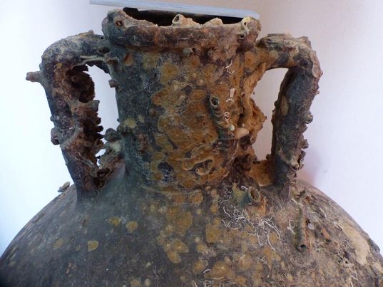
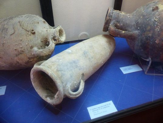
An oneraria ship, sailing towards Ostia with its cargo of commercial amphorae, between the end of the 2nd and the first half of the 3rd century AD, after a series of intermediate stops, from the Palestinian region to Cilicia, from Turkey to Crete to Corinth to Messina, in continuing its route northwards, suddenly interrupts its voyage: Shipwrecked towards Punta Mazza, north-east of Capo Milazzo, it dispersed in the depressions of the seabed both its cargo and its ship's equipment, which included amphorae of various types and productions, intended to contain wine, as indicated by the 'resin' treatment on the inside, an oil-lamp, a bronze mirror, a handle and a jug bottom, Corinthian relief ceramic cups, unworked lead sheets, an anchor log with a wooden core (on display outside).
The wreck of Punta Mazza, reported in 1991, was the subject of a first excavation campaign, conducted in 1996 by the Messina Superintendency, and of a more limited intervention conducted in 1997. The wreck of the oneraria is located in a rocky and steep seabed, which, unfortunately, has not favoured the preservation of the cargo in its integrity.
⁃ Showcase 2
From the shoreline in front of Marina Garibaldi, within the wide inlet of the port, up to the Cross of the Sea, as well as from the Liparoti Cove, further to the north-east of the same eastern shoreline, between Punta Cirucco and Punta Rotolo, respectively, come batches of material whose typological and chronological heterogeneity has led to the hypothesis that they pertain to 'discharges' made by boats at anchor or from dry land.
The first lot includes mostly larder, table and fire ceramics, dating from the 11th to the 20th century, of Sicilian production, especially protomaiolica and glazed, or of more specifically local production (Patti), generally pots, plates, containers for sauces and brines.
To the second lot belong materials of more varied typology and chronology, ranging from commercial amphorae, dating back to the late archaic Greek period and beyond the Roman-Imperial period, to bowls, bowls, cups, jugs, pots and pans that can be traced back to more recent production areas, between the 13th and 20th centuries.
Protected from the Libeccio and Maestrale winds, the inlet must have been a safe shelter, especially for those coming from the Aeolian Islands, as the place name itself would indicate. The presence of a spring allowed the supply of fresh water and a flight of steps cut into the rock guaranteed access to the Capo Milazzo promontory, as can be seen from a 17th century map by Francesco Negro.
All the artefacts found (a total of 266 items) testify to the prolonged use of the inlet as a maritime port of call and confirm what is reported by Filippo Geraci, author of a 17th-century pilot's book, and by an 18th-century map, preserved in the archives of Naples, which indicates the Cala dei Liparoti as a suitable place for anchoring.
⁃ Showcase 3
From a series of seizures made by the Coast Guard and from free private donations comes a series of commercial amphorae of certain interest, traceable to Greek (Samos, Crete, Kos), Oriental and Roman production.
⁃ The outer court
The external courtyard of the Museum has been functionalised for the display of other archaeological evidence.
Along the northern perimeter wall, close to the access to the underwater archaeology room, a number of lead anchor logs and a counter anchor from the Baia di Ponente/`Ngonia are on display. They are the result of seizures and/or donations by private individuals, originally the equipment of ships that, for various reasons, had stopped in this inlet of the coastline and had lost their anchors, probably due to the insidiousness of the seabed, which was rocky in places.
Close to the eastern end wall, an interesting kiln for the production of ceramics has been returned to public use. It was found in 2011 in via Cosenz, in an area originally occupied by the Greek necropolis, as confirmed by the burials within transport amphorae brought to light in the same area at different heights.
As is well known, from the moment of foundation, the Greek colonists needed to manufacture pottery for everyday use. The existence of local production had therefore been documented at Mylai by the pottery found and the analyses conducted on the mixtures, which had confirmed the hypotheses made on the basis of the archaeological evidence.
The discovery of via Cosenz, acquires, in this sense, particular importance, because it offers direct data to hypothesise the location of a part of the area destined, between the end of the 4th and 3rd centuries B.C., for ancient ceramics.
Per le informazioni qui riportate e per approfondire: Tigano G., Ollà A., Antiquarium “Domenico Ryolo”. Sezione subacquea., Milazzo 2011; Tigano G., Coppolino P., Milazzo. L'Antiquarium e altre emergenze archeologiche nell'area urbana. Breve guida., Palermo 2017.